ermmmmm
skang dah xnak promote air terjun g
bb asgnmnt dah habis
i'Allah dapt mrkah yg ok kot............
skang ngah bz ngan exam lak
Wednesday, October 21, 2009
Tuesday, September 15, 2009

onepiecenowar members

hello everybody......im nurul and azra...we are friends........ pair groups 4 these blog.....this is first the time we are doing this for our assignment.....thanks to Miss Azleen, without her help we would never had complete to do these blog.......because both of us never know how to do a blog before we take her lecturer....we always heard people had their own blog...but never wannat try to have one...........because for us..blog is something was not important.........then 1 day we got these task from our lecturer Miss Azleen.....really shock and do not what to do......Alhamdullilah.....both of us finally done.......hope you all can tell us how our blog is..........we are waiting in curiousity....hehehehehehe
onepiecenowar means both of us love the piece of nature and hope our Malaysia would never fall in war anymore because we never can bear what will happen at the future...we chose the waterfalls for our task..because ..almost 60% of our people does not know that there were beautiful wterfalls we had......although the place quiet hidden but it can be an explorer to those whom loves exciments of tracking ......... enjoy for it ...........
waterfalls at Terengganu

Terengganu is always thought of as a State with sandy beaches.
In fact it is a mountainous land with only a narrow strip of beach. Most areas inland are sparsely populated. Many waterfalls are yet to be identified.
Traditional waterfalls and their parks are now being spruced up and very well maintained. They are worth visiting.
In fact it is a mountainous land with only a narrow strip of beach. Most areas inland are sparsely populated. Many waterfalls are yet to be identified.
Traditional waterfalls and their parks are now being spruced up and very well maintained. They are worth visiting.
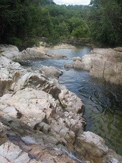
Lata Tembakah
| State | Terengganu |
| Location | 25 km south of Jertih |
| Coordinates and map | N05° 35.17' E102° 26.83' |
| Water Source | Stream |
| Waterfall Profile | Vertical Falls & Cascades |
| Accessibility | Nature park |
The Tembakah Waterfalls are probably the most impressive falls of Terengganu. The Hutan Lipur Lata Tembakah is clearly signposted and can be reached from Jertih. Coming from K. Terengganu a shortcut is possible by taking the T142 near Kg Jabi.
 This is the sign you will see, when you come from K. Terengganu
 The park is well maintained with many facilities
The first waterfalls are actually more like cascades. They have nice, large pools, which make them perfect for family outings. Not surprisingly, this park can be crowded!
 The first cascade
 Some of the cascades can be used as (bumpy) slides.
When you follow the trail along the river, you reach the main fall of the park. It is number 4 of the list.
 The nr 4 waterfall is very impressive
 It is a tall fall with an estimated altitude of 80 meters
 From this fall you can continue to the upper falls.
To reach the upper falls, there are two possibities. First, you can choose the jungle trail, which is clearly signposted. The other way is to scramble upwards at the right side of the main fall. Interesting but not easy.
 View of the mail fall, seen when scrambling uphill
 At the top of the main fall. Deep down the crowd of visitors is visible.
 After the main fall there are some quiet stretches
 View of the mail fall, seen when scrambling uphill
 At the top of the main fall. Deep down the crowd of visitors is visible.
 After the main fall there are some quiet stretches
The upper falls are also very impressive and as it takes some effort to reach them, they will be quiet even when there is a crowd.
 A slightly smaller brother of the main fall
 Also here a beautiful pool
 One of the quiet stretches
 quiet....
 and wild....
 The last waterfall
 A slightly smaller brother of the main fall
 Also here a beautiful pool
 One of the quiet stretches
 quiet....
 and wild....
 The last waterfall
waterfalls at Selangor

The State of Selangor has a state boundary at the western slopes of the Main Range. The annual Monsoon rains and tropical storms results in major rivers with many tributaries and waterfalls. Rainfall level is fairly consistent on this windward side of the Main Range.
Hence, the size of waterfalls found in Selangor varies not much in size the whole year round.
Hence, the size of waterfalls found in Selangor varies not much in size the whole year round.
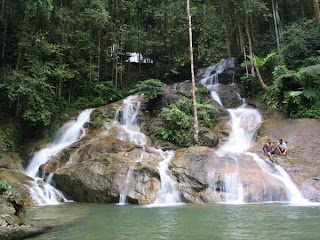
The Kanching Falls
| State | Selangor |
| Location | Between Selayang and Rawang |
| Coordinates and map | E101° 37.19' N 3° 18.13' |
| Water Source | Stream |
| Waterfall Profile | 7 Falls, most vertical ones |
| Accessibility | Public Transport, Trekking |
Pleasure park of Kuala Lumpur
It may come as a surprise for some, but quite near to the bustling metropolis of Kuala Lumpur, there are many beautyful nature spots.
One of them is the Hutan Lipur Kanching. This well maintained recreation park is located off the trunk road nr 1 to Ipoh, between Selayang and Rawang.
Bus nr 43 will bring you there from Central Market in less than one hour.
The first part is perfectly suited for family trips and can be crowded during weekends.
There are many nice picknick spots along the small stream which is meandering quietly between meadows and does not indicate that there are waterfalls nearby.
Just follow the cemented path...!
Seven waterfalls...!!

Where does one waterfall end and the next one start?
This can be a bit confusing here, because there are many falls, covering a total height difference of about 200 meters.
The first fall is a romantic and secluded one.
But not very suitable for bathing.
Near the second fall an attempt has been made to construct a kind of swimming pool.

The Kapor Fall
The next fall, the Kapor Fall, could be appropriately called THE Kanching Fall. There are dressing rooms here, toilets and shelters.
Take care when you leave your belongings here and go for a relaxing swim, because there are many curious monkeys around!

The next fall is a big one. Can you still call this a fall or is it just the stream going down steeply for about 60 meters?
Take care, this place is not suitable for swimming anymore, although some trees manage to survive in these adverse conditions.

This can be a bit confusing here, because there are many falls, covering a total height difference of about 200 meters.
The first fall is a romantic and secluded one.
But not very suitable for bathing.
Near the second fall an attempt has been made to construct a kind of swimming pool.

The Kapor Fall
The next fall, the Kapor Fall, could be appropriately called THE Kanching Fall. There are dressing rooms here, toilets and shelters.
Take care when you leave your belongings here and go for a relaxing swim, because there are many curious monkeys around!

The call of advenure...
At the top there is waterfall nr 4 and here is the end of the concrete steps. But there is more to see, although it will require more effort and some scrambling.
You have to climb up steep slopes, there are trails on both sides of the stream, the left trail is easier but not as interesting as the one on the right side.
The next fall has no swimming pool, but a perfect shower!

The next fall is a big one. Can you still call this a fall or is it just the stream going down steeply for about 60 meters?
Take care, this place is not suitable for swimming anymore, although some trees manage to survive in these adverse conditions.

At the top of waterfall nr 6, the landscape changes suddenly. Climbing out of the valley, for the first time you have a clear view of the opposite site, far away. There is one last waterfall, a jewel, watch the colours of the rocks here!
Rest, enjoy and relax.
If you keep going on(no trail, just follow the river bed) you will find no more falls, but quiet, pristine jungle. Where does it end? Try to find out for yourself!

Rest, enjoy and relax.
If you keep going on(no trail, just follow the river bed) you will find no more falls, but quiet, pristine jungle. Where does it end? Try to find out for yourself!

Monday, September 14, 2009
waterfalls at Sarawak

By far the largest state of Malaysia, Sarawak has numerous waterfalls, many of which still have to be explored
Ranchan Falls
| State | Sarawak |
| Location | Near Serian |
| Coordinates and map | N 01 08.59' E 110 35.02' |
| Water Source | Stream |
| Waterfall Profile | Cascades and falls |
| Accessibility | From carpark |
The Recreational park of Ranchan is located just south of Serian, about 60 km from Kuching. Easy access from the main nr 1 highway. The park is well maintained, as is generally the case in Sarawak.
 Ranchan park, the rules and regulations
 A colorful bridge crosses the stream
A good footpath leads to the falls and to a suspension bridge where you can cross to the other side of the river.
 One of the Ranchan falls
 The suspension bridge
Not surprisingly the park is popular with the locals. A perfect destination for a pleasant Sunday afternoon.


waterfalls at Sabah

This state in the Northern part of Borneo, is largely covered with tropical rainforest. Many of its numerous waterfalls still have to be explored
Mahua Waterfall
| State | Sabah |
| Location | 15 minutes from Tambunan |
| Coordinates | N 5°40' E 116°22' (Tambunan) |
| Water Source | River |
| Waterfall Profile | Vertical Fall |
| Accessibility | 6 km along a dirt road followed by an easy 15 minute walk |
After making that turn, you trundle along a dirt road for 6 km. The first stretch of the road is in relatively good condition, but it gets trickier the farther in you go. My guess is that an ordinary car would encounter difficulties in wet weather. We were in a 4WD, but because it was not one of those rugged 4 x 4 work horses, we did experience some sticky moments.
Eventually, we came to a large clearing along which a river rushed. This marked the end of the road. The track was rather muddy and to avoid getting our vehicle stuck, we walked the rest of the way in to the Mahua Sub-station which had been financed by the Japan International Co-operational Agency (JICA). A friendly caretaker there maintains an office and collects an entrance fee of RM3 per person. For that fee, you also get to use the extremely clean toilets.

Passing by a village on the dirt road to the Mahua Fall. Notice the pine tree.
 The road ends here. Because it was muddy, we parked and walked in to the Mahua Sub-station which you can see in the far distance.
 The trail to the waterfall. This is so well-marked and well-kept that it will be impossible to get lost.
 The road ends here. Because it was muddy, we parked and walked in to the Mahua Sub-station which you can see in the far distance.
 The trail to the waterfall. This is so well-marked and well-kept that it will be impossible to get lost.
The 500 metre walk along a distinct and well-maintained trail to the waterfall is an extremely pleasant stroll through a secondary forest of dipterocarp trees, undergrowth, ferns, shrubs and bamboo dense enough to shut out most of the sun’s heat. Butterflies, mainly the Tufted Jungle King, fluttering along the trail added flashes of colour to the otherwise intense green of the forest.


The river which runs by the trail.
 Another view of the river.
 Sungai Lobou
Two tributaries, the Sg Lobou and the Sg Kulanggi gush down as little waterfalls of their own to join the main river which is never out of sight or earshot.
 Sungai Kulanggi
 Some parts of the trail are cemented for easy access.
 The dense dipterocarp forest through which the trail passes.
At the end of the trail, the Mahua Waterfall tumbles down in an agitated vertical column of water, sending up a continuous misty spray as it crashes into the pool below. The height of the Fall is uncertain. One source puts it as 9 metres, another 15 metres and yet another 17 metres. I’m not sure, too, whether the small pool is safe for swimming but I can imagine that the strong currents stirred up by the Fall would put paid to all such intentions.
 The fall becomes visible
 The Mahua Fall
 The fall in all its glory
Shelters and benches are provided for picnickers. There were, however, only four other people besides us that day we went. Difficulty of access has probably discouraged many people from visiting the Fall which is not a bad thing considering the difficulty of maintaining cleanliness in the face of large crowds.
 Around the Fall area are shelters, benches and picnic tables for picnickers
Subscribe to:
Posts (Atom)
